|
|
Zeile 8: |
Zeile 8: |
| Gent, Belgie~The city Ghent~Ghent is awesome~ Marker 13 rot.png ~ ~Ghent | | Gent, Belgie~The city Ghent~Ghent is awesome~ Marker 13 rot.png ~ ~Ghent |
| Brussel~The city Brussel~The capital of Belgium~ Marker 11 rot.png ~ ~Brussels | | Brussel~The city Brussel~The capital of Belgium~ Marker 11 rot.png ~ ~Brussels |
| Antwerp~The city Antwerp~ Label Lindelaufstr.1 3.png ~ ~Antwerp | | Antwerp~The city Antwerp~Label Lindelaufstr.1 3.png ~ ~Antwerp |
| </display_map> | | </display_map> |
|
| |
|
| {{#display_map:Höhenhaus~Der Stadtteil Höhenhaus is a really nice city and there is plenty of Club Mate~ Text Holweide ~Label Lindelaufstr.1 3.png ~ Letzter Parameter; | | {{#display_map:Höhenhaus~Der Stadtteil Höhenhaus is a really nice city and there is plenty of Club Mate~ Text Holweide ~Label Lindelaufstr.1 3.png ~ Letzter Parameter; |
| Holweide~Der Stadtteil Holweide ist auch ein interessanter Stadtteil~ Marker 11 rot.png | | Holweide~Der Stadtteil Holweide ist auch ein interessanter Stadtteil~Marker 11 rot.png |
| |width=100%|height=400px|static=no|layers=OpenStreetMap.DE|geojson=Höhenhaus;geojson=Holweide}}</span><span style="font-size:80%">[https://www.offenedaten-koeln.de/dataset/stadtteile Datenquelle: Stadt Köln – offenedaten-koeln.de]</span> | | |width=100%|height=400px|static=no|layers=OpenStreetMap.DE|geojson=Höhenhaus;geojson=Holweide}}</span><span style="font-size:80%">[https://www.offenedaten-koeln.de/dataset/stadtteile Datenquelle: Stadt Köln – offenedaten-koeln.de]</span> |
| |} | | |} |
Grundsätzlicher Test mit display-map
Die Karte wird geladen …
{"minzoom":false,"maxzoom":false,"mappingservice":"leaflet","width":"auto","height":"350px","centre":false,"title":"","label":"","icon":"","lines":[],"polygons":[],"circles":[],"rectangles":[],"copycoords":false,"static":false,"zoom":false,"defzoom":14,"layers":["OpenStreetMap"],"image layers":[],"overlays":[],"resizable":false,"fullscreen":false,"scrollwheelzoom":true,"cluster":false,"clustermaxzoom":20,"clusterzoomonclick":true,"clustermaxradius":80,"clusterspiderfy":true,"geojson":"","clicktarget":"","imageLayers":[],"locations":[{"text":"\u003Cb\u003E\u003Cdiv class=\"mw-parser-output\"\u003E\u003Cp\u003EThe city Berlin\n\u003C/p\u003E\u003C/div\u003E\u003C/b\u003E\u003Cdiv class=\"mw-parser-output\"\u003E\u003Cp\u003EBerlin is a really nice city and there is plenty of Club Mate\n\u003C/p\u003E\u003C/div\u003E","title":"The city Berlin\n","link":"","lat":52.510885,"lon":13.3989367,"icon":"/images/1/1a/Sigwinstr._21_Kemp_S._30_mini.jpg"},{"text":"\u003Cb\u003E\u003Cdiv class=\"mw-parser-output\"\u003E\u003Cp\u003EThe city Amsterdam\n\u003C/p\u003E\u003C/div\u003E\u003C/b\u003E\u003Cdiv class=\"mw-parser-output\"\u003E\u003Cp\u003EAmsterdam is the capital of \u003Cb\u003EThe Netherlands\u003C/b\u003E\n\u003C/p\u003E\u003C/div\u003E","title":"The city Amsterdam\n","link":"","lat":52.3730796,"lon":4.8924534,"icon":"/images/6/65/Marker_13_rot.png"}],"imageoverlays":null}
Die Karte wird geladen …
{"minzoom":false,"maxzoom":false,"mappingservice":"leaflet","width":"auto","height":"300px","centre":false,"title":"","label":"","icon":"","lines":[],"polygons":[],"circles":[],"rectangles":[],"copycoords":false,"static":false,"zoom":false,"defzoom":14,"layers":["OpenStreetMap"],"image layers":[],"overlays":[],"resizable":false,"fullscreen":false,"scrollwheelzoom":false,"cluster":false,"clustermaxzoom":20,"clusterzoomonclick":true,"clustermaxradius":80,"clusterspiderfy":true,"geojson":"","clicktarget":"","imageLayers":[],"locations":[{"text":"\u003Cb\u003E\u003Cdiv class=\"mw-parser-output\"\u003E\u003Cp\u003EThe city Ghent\n\u003C/p\u003E\u003C/div\u003E\u003C/b\u003E\u003Cdiv class=\"mw-parser-output\"\u003E\u003Cp\u003EGhent is awesome\n\u003C/p\u003E\u003C/div\u003E","title":"The city Ghent\n","link":"","lat":51.0538286,"lon":3.7250121,"icon":"/images/6/65/Marker_13_rot.png","inlineLabel":"Ghent\n"},{"text":"\u003Cb\u003E\u003Cdiv class=\"mw-parser-output\"\u003E\u003Cp\u003EThe city Brussel\n\u003C/p\u003E\u003C/div\u003E\u003C/b\u003E\u003Cdiv class=\"mw-parser-output\"\u003E\u003Cp\u003EThe capital of Belgium\n\u003C/p\u003E\u003C/div\u003E","title":"The city Brussel\n","link":"","lat":50.8465573,"lon":4.351697,"icon":"/images/0/0c/Marker_11_rot.png","inlineLabel":"Brussels\n"},{"text":"\u003Cb\u003E\u003Cdiv class=\"mw-parser-output\"\u003E\u003Cp\u003EThe city Antwerp\n\u003C/p\u003E\u003C/div\u003E\u003C/b\u003E\u003Cdiv class=\"mw-parser-output\"\u003E\u003Cp\u003ELabel Lindelaufstr.1 3.png\n\u003C/p\u003E\u003C/div\u003E","title":"The city Antwerp\n","link":"","lat":51.2211097,"lon":4.3997081,"icon":"","group":"Antwerp"}],"imageoverlays":null}
Die Karte wird geladen …
{"minzoom":false,"maxzoom":false,"mappingservice":"leaflet","width":"100%","height":"400px","centre":false,"title":"","label":"","icon":"","lines":[],"polygons":[],"circles":[],"rectangles":[],"copycoords":false,"static":false,"zoom":false,"defzoom":14,"layers":["OpenStreetMap.DE"],"image layers":[],"overlays":[],"resizable":false,"fullscreen":false,"scrollwheelzoom":true,"cluster":false,"clustermaxzoom":20,"clusterzoomonclick":true,"clustermaxradius":80,"clusterspiderfy":true,"geojson":[],"clicktarget":"","GeoJsonSource":null,"GeoJsonRevisionId":null,"imageLayers":[],"locations":[{"text":"\u003Cb\u003E\u003Cdiv class=\"mw-parser-output\"\u003E\u003Cp\u003EDer Stadtteil H\u00f6henhaus is a really nice city and there is plenty of Club Mate\n\u003C/p\u003E\u003C/div\u003E\u003C/b\u003E\u003Cdiv class=\"mw-parser-output\"\u003E\u003Cp\u003EText Holweide\n\u003C/p\u003E\u003C/div\u003E","title":"Der Stadtteil H\u00f6henhaus is a really nice city and there is plenty of Club Mate\n","link":"","lat":50.9856509,"lon":7.0348204,"icon":"/images/6/6e/Label_Lindelaufstr.1_3.png","group":"Letzter Parameter"},{"text":"\u003Cb\u003E\u003Cdiv class=\"mw-parser-output\"\u003E\u003Cp\u003EDer Stadtteil Holweide ist auch ein interessanter Stadtteil\n\u003C/p\u003E\u003C/div\u003E\u003C/b\u003E\u003Cdiv class=\"mw-parser-output\"\u003E\u003Cp\u003EMarker 11 rot.png\n\u003C/p\u003E\u003C/div\u003E","title":"Der Stadtteil Holweide ist auch ein interessanter Stadtteil\n","link":"","lat":50.9693032,"lon":7.0495739,"icon":""}],"imageoverlays":null}
Datenquelle: Stadt Köln – offenedaten-koeln.de
|}
Interaktiver Übersichtsplan zur Sigwinstraße (bisher Test, zum Öffnen anklicken):
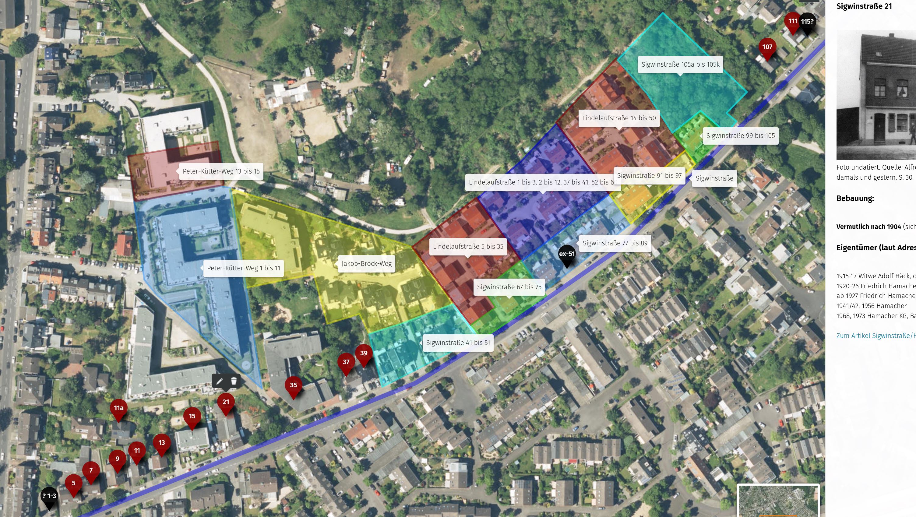
Interaktiver Übersichtsplan der Sigwinstraße - Test
Das folgende Beispiel hat zwar nichts mit Höhenhaus zu tun, dient aber hier als Beispiel, wie ein umap über ein Bild in werden könnte:
Interaktiver Übersichtsplan der Köln Klöster (zum Öffnen anklicken):
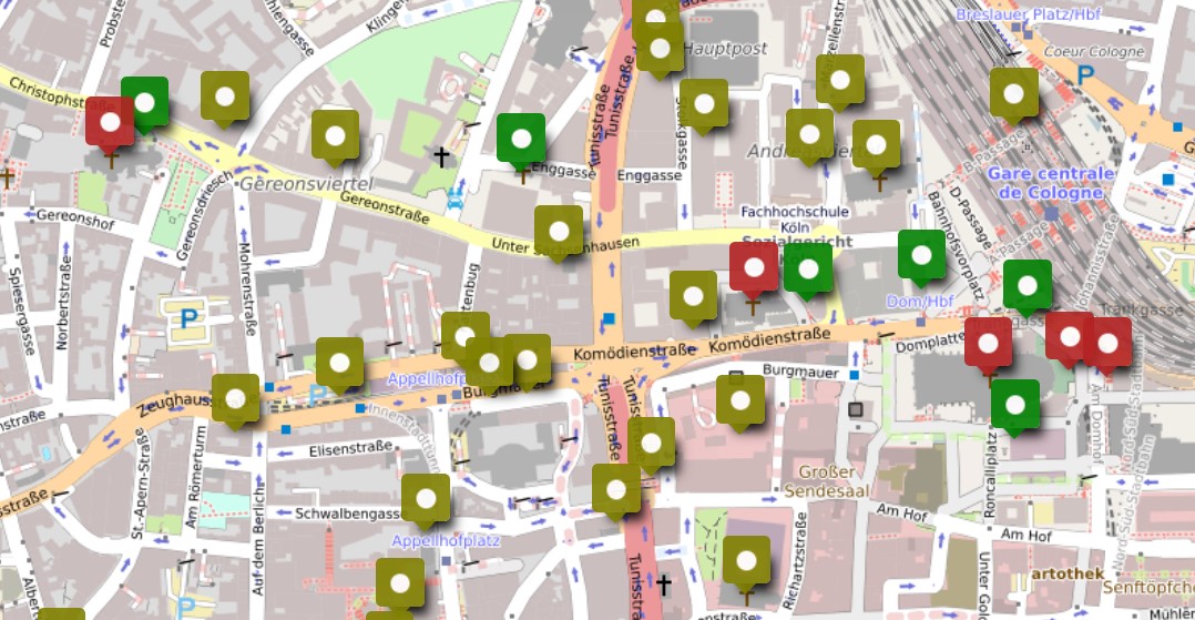
Interaktiver Übersichtsplan der Kölner Klöster